
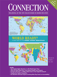
 I got a call out of the blue from a man who designed maps we used on the cover of our Fall 2006 edition of The New England Journal of Higher Education titled World Ready? A New View of the Global Student Marketplace.
The man was Bob Abramms, founder of Amherst Mass.-based ODTInc.
Our cover juxtaposed two of his maps: a Hobo-Dyer Map and a Population Map, in which, the larger a country’s population is, the bigger it appears on the map.
His outreach caught my attention for a few reasons. First, the world has only gotten harder to read since we used those maps for the journal. Our higher education institutions depend increasingly on international enrollment to survive and our country thrives on immigration, despite Donald Trump. Second, I’ve always been something of a map enthusiast, even considered going to Clark U for cartography and invented a well-mapped Harchester.
But Abramms’s reason for calling was that he’s retiring and selling his map-making business in mid-October 2019. He’s donating a lot of the maps. And he thought since we used one before, we might be able to use one again. I sadly told him that I didn’t think I had use for one of the physical maps, but that I would spread the word that they are available to good causes.
To wit, please take a look at ODT’s page here for free downloads.
